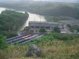
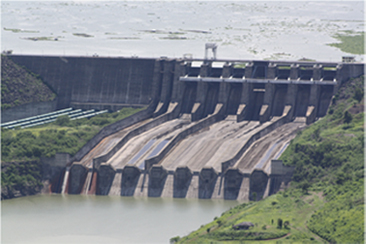
Magat Dam
Magat Dam is a large rock-fill dam on the island of Luzon in the Philippines. The dam is located on Magat River, a major tributary of Cagayan River. Construction of the dam started in 1975 and completed in 1982. Magat Dam is one of the largest dams in the Philippines and has two primary purposes: as a source of irrigation water and as a provider of hydroelectric power.
History
The construction and appurtenant structures was authorized by P.D. 693 signed on May 7, 1975 by the late President Ferdinand E. Marcos. The Magat Dam was constructed in 1978 and inaugurated by the Late Pres. Ferdinand E. Marcos on October 27, 1982[1] and started operations in 1983.[2] Implementation of this multipurpose project was based on the preliminary study conducted in 1973 by the National Irrigation Administration (NIA) with the assistance of the United States Bureau of Reclamation (USBR) and the United States Agency for International Development (USAID). Subsequent detailed and extensive dam site investigation and engineering studies further confirmed the feasibility of what is now known as NIA's most daring infrastructure project and one of Asia's biggest dams today. It was Southeast Asia's first large multipurpose dam. The dam is part of the Magat River Multipurpose Project (MRMP) which was financed by the World Bank and whose purpose is to improve on the existing Magat River Irrigation System (MARIS) and to triple the production of rice in the Cagayan River basin. The project was jointly financed by the Philippine Government and the World Bank which extended a US$150M loan to finance the foreign exchange requirement. In addition, a US$9M loan from Bahrain was obtained for the purchase of other equipment for the diversion tunnels, soils laboratory and model testing. The total project cost is US$3.4B (yr. 1975).
Geography
The Magat Dam is located on the Magat River at the boundary between the municipalities of Alfonso Lista in the province of Ifugao and Ramon in Isabela both on the island of Luzon, approximately 350 kilometres (220 mi) north of Metro Manila. The Magat River is the largest tributary of the Cagayan River, the longest river in the country.
Features
Magat High Dam
Height: 114 metres (374 ft)
Crest Length: 4,160 metres (13,650 ft)
Volume of Rocks & Earth Materials: 18 million cubic meters
Concrete = 1.00 million cubic meters
Spillway
Length = 500 metres (1,600 ft)
Width = 164 metres (538 ft)
Discharge Cap.= 30,600 cubic meters
Radial Gates = 7 sets
Orifice Gates = 2 sets
Diversion Tunnels
Number: 2
Diameters: 2 metres (6.6 ft)
Ave.Length: 630 metres (2,070 ft)
Reservoir
Storage Cap.at Full Supply Level(FSL): 1.08 billion cubic meters
Area at FSL : 45 square kilometres (17 sq mi)
Area at min. Supply Level : 15 square kilometres (5.8 sq mi)
Elevation at FSL : El. 193 metres (633 ft)
Maximum Flood Level : El. 197.6 metres (648 ft)
Live Storage : 810 million cubic meters
Power House
Installed Capacity : 360 MegaWatts
Additional Capacity: 180 MegaWatts
Total : 540 MegaWatts